While celebrating the 50th anniversary of Earth Day, it is virtually impossible not to consider the contribution of geographic information systems and science in studying and solving complex problems in Earth Sciences. Given the fact that the first mention of a “geographic information system” occurred only 8 years before the first Earth Day celebration, in a paper by Roger Tomlinson, I decided to revisit the evolution of GIS over half a century. The following is by no means a comprehensive discussion on the history of GIS, but rather a summary of what I personally deem as evolutionary highlights over time.
1960’s – The Field and a System

- As computers developed and the earliest concepts of quantitative and computational geography emerged, the field of geographic information systems (GIS) originated.
- In 1963, Roger Tomlinson was commissioned by the Canadian government to create a natural resource inventory that can easily be managed. Tomlinson envisaged the use of computers to undertake this task and he designed an automated computing process that became the very first GIS, the Canada Geographic Information System (CGIS)
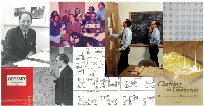
- In 1964, Howard Fisher developed one of the first mapping software programmes (SYMAP, see p.2) at Northwestern University
- In 1965, Fisher established the Harvard Laboratory for Computer Graphics, which not only created the first computer mapping software, but also became the first research centre for spatial analysis and visualisation.
- In 1966, the Urban and Regional Information Systems Association (URISA) was established by a group of urban planning and information systems professionals and promotes various aspects of GIS to this day
- In 1969, Jack and Laura Dangermond founded the consulting firm, Environmental Systems Research Institute, Inc. (Esri), which applied computer mapping and spatial analysis to assist land use planners to enhance decision-making
1970’s – Product Development
- In 1970, the US Census Bureau produced the first geocoded census by applying a topological model. The topological structure of street segments was coded with ID’s and addresses with X,Y coordinates
- The Harvard Laboratory developed and distributed (in 1974) the POLYVRT program for the conversion of various data formats, using the topological model that was adopted by the US Geological Survey and Census Bureau
- In 1977, this work secured a grant from the National Science Foundation and also a symposium for international research scholars, which resulted in the development of the ODYSSEY system (see p.7-8).
1980’s – Going Commercial

- With the enhancement in computing power, Esri improved software tools and the continuous undertaking of projects to solve real-world problems resulted in the development of robust GIS tools that could be applied more widely
- Consequently, Esri gained recognition from academia regarding spatial analysis methodologies and the need for tools resulted in the development of the first commercial GIS product, ARC/INFO (ArcInfo)
- In 1982, this product was released and Esri’s evolution into a software company was initiated
- In 1984, Geographic Resources Analysis and Support System (GRASS GIS) was released as open source software suite
- In 1986, development was undertaken of the first MapInfo desktop software
- In 1987, the UK’s Economic and Social Research Council (ESRC) established four regional research laboratories for four main purposes: data management and provision of spatial data archive, software development, spatial analysis and research training and professional development
- In the same year the Committee of Inquiry into the Handling of Geographic Information recommended that the British Ordnance Survey should transition to a full digital environment (Waters, 1998)
1990’s – Desktop GIS and a Science

- Esri released the desktop solution Arcview throughout the 1990’s
- Further development of the Internet and enhance computing power resulted in a widespread adoption of GIS
- In 1992, Michael Goodchild made a major contribution to the field of GIS by stating in a publication that the discipline should transition from a systems to a science-orientated position (Goodchild, 1992)
- Hence, focus should now shift from ‘how to get geographic information into the system’ to ‘how to handle and exploit this data held in the system’
- Consequently, the discipline of GIScience was born and resulted in the enhancement of spatial data analysis and visualisation tools and techniques
2000 – Desktop GIS, Open and Online Developments

- In 2002, Gary Sherman started development of the open source Quantum GIS software, now known as QGIS
- In 2004, OpenStreetMap was founded on the foundation of voluntary GIS, which gained momentum
- In 2005, Google Maps and Google Earth were launched, providing interactive online mapping and a digital representation of the globe respectively
- In 2007, Google launched Street View as web application and component of Google Maps and captured more than 10 million miles of imagery across 83 countries in the first 10 years
- In 2009, Ordnance Survey data became freely available to the public
The last two decade have seen an immense development drive in the field of GIS and the integration of related processes, methodologies, techniques and toolkits. From Building Information Modelling and Digital Twins to Smart City development and Urban Analytics. As we embark on this journey to an ultimately digital world, the geographic information system and science will continue to play a substantial role.

Finally, I believe that the application and integration of GIS with toolkits for modelling dynamical systems (ABM and cellular automata) and generating virtual urban scapes (CityEngine & ArcGIS Urban with Unity or Unreal) will continue to play a pivotal role in sustainability and climate action (the theme of Earth Day 2020).
References:
Goodchild, Michael F. 1992. “Geographical Information Science.” International Journal of Geographical Information Systems, 6(1): 31–45.
Waters, Nigel. 1998. “Geographic Information Systems.” Encyclopedia of Library and Information Science, 63: 98–125.
StoryMap on Earth Challenge 2020
High-End 3D Visualisation with CityEngine, Unity and Unreal
GIS & Agent-based Modelling: Urban Growth Model by Andrew Crooks
